Dec 31, 2011

Mt. Balatukan : Itinerary

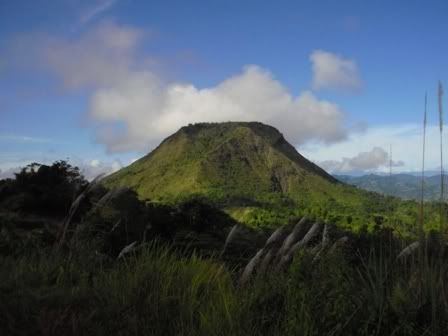
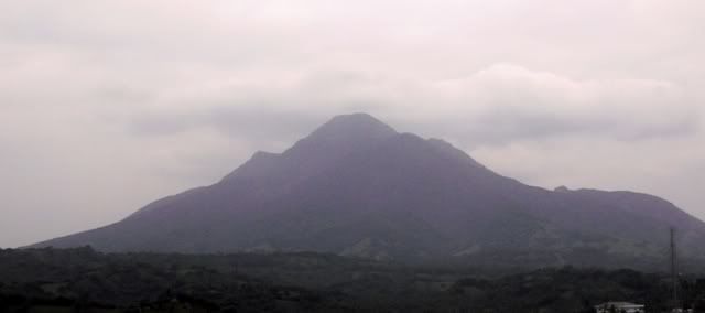
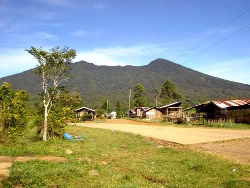
View from Sitio Civoleg: Pamalihi peak (false summit) to the rightmost

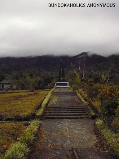
Mt. Balatukan forms one of the gargantuan ranges that pillars Misamis Oriental. This strato-volcano has an estimated elevation of 2,450masl (Wikimapia) and is considered as the highest peak in Misamis Oriental looming over the whole Gingoog City and nearby towns along the National Highway. The summit is called Rosas Pandan Peak, and there is an adjacent prominent peak the locals refer to as Pamalihi peak.

Dec 28, 2011

The Inner Traveller of a Mountain Climber


A: Age you made your first international trip
Four I think, to see a cousin in Japan… visited Disneyland. That trip became an adventure for all of us (TNT, deportation and all). That Japan trip lasted for a month, and costed me two notches down in the honor roll. And had I known that I would be this mountain climber hoolabaloo, I would have insisted climbing Mt. Fuji since at that tender age of 4, I was already mesmerized by Mt. Arayat.

Tokyo Disneyland, 1986?

Dec 27, 2011

Mt. Mayapay : Itinerary

highest peak in Butuan City, Agusal del Norte (Mindanao)

Mount Mayapay is one of the lesser known peaks in the Philippines, but well renowned in its home in Butuan City. Standing approximately 675masl as per Butuan Tourism or 719masl per article in a newsflash (http://www.newsflash.org/2004/02/ht/ht006118.htm), Mt. Mayapay is one proud local of Butuan City.

Dec 25, 2011

Timeline of My Hiking Footwear


To those persons who knew me better as a hiker, they would probably tell you that I prefer trekking with slippers, crocs, or no footwear at all. In my 4 years of climb experience, I had only two hiking shoes.

Dec 17, 2011

Wanted : Postcard Recipients

It just hit me that I want to experience the feeling of sending postcards. In our times where communication is just a matter of a touch of button, sending snail mails is becoming a thing of the past. Before this practice becomes long forgotten, I will try to send 9 postcards in total during my upcoming Christmas trip. This is also my way of thanking my readers. :)

If interested, please leave a comment stating your name and desired mailing address. I will not publish your comments. If there are more than 9 interested parties, then I will try to select just 9 through a raffle.

I will fly on the 25th, and will return on the 31st. Please have your entries in before my flight so I could have the list ready before I leave.

PS: this was also an idea sparked when a blogger from Oz asked for my mailing address so she could send me a postcard for Christmas.

Happy Holidays!


Update:
Since there had been a low turn-out of interested parties, this is going to be on a first-come first-served basis. Here is the list of the future recipients of the postcards, divided in 3 batches since I will be in 3 provinces in my 7 days of backpacking.


Dec 10, 2011

Kota Kinabalu: How Much I Spent on the 8D7N Trip

Malaysian Ringgit

PLANE FARE
We got a deal last year for the Kota Kinabalu flight from Manila. Cebu Pacific who regularly holds a Piso Fare seat sale every now and then offered seats for only Php150.00 per head, baggage not included. My friend Liz booked for the two of us, without return flight.Last August, I booked a return flight to Manila for RM114.89 under a Piso Fare (what a difference, right?).

Dec 9, 2011

Get Me Out of Here!: Kota Kinabalu International Airport (Terminal 2)

KKIA 2

Kota Kinabalu City in Sabah, Malaysia has 2 main international airports….one is Terminal 1 which mainly serves Malaysian Airlines (there are other carriers though), and Terminal 2 which caters mostly to Air Asia and Cebu Pacific. Kota Kinabalu International Airport Terminal 2 or much popular as KKIA2 or Terminal 2 is much smaller than its counterpart, and is located opposite of the KKIA Terminal 1.

Nov 25, 2011

Walk This Way: Mt. Manabu

After a dilapidated wooden kubo, keep to the left.

Nov 12, 2011

Wag BiBITaw!!!: My First Bitbit Bridge Rappel Experience

Let’s get it on! Wait, wait….


Out of desperation for a training on my upcoming Via Ferrata stint, I finally coaxed myself to join an event by The Extreme Adventure Zone (TEAZone). Sir Marc the Organizer is a friend so I enjoyed the privilege of paying on the spot instead of their policy of depositing the full payment before being confirmed. With me are my 2 best buds, Liz and Nette who are not new to the outdoor life themselves. It was my lucky weekend as both of them are free to join me.

Oct 30, 2011

Remembering Flight 387

The shrine silently waiting for visitors...

This post was inspired by a trip to Brgy. Lunotan during Undas 2011, a place cradled by Gingoog mountains such as Mt. Balatukan range and Mt. Sumagaya range. I managed to climb Mt. Balatukan up to the summit, termed as Rosas Pandan Peak by local mountaineering group KAPLAG. I am also scheduled to climb Mt. Lumot, the site of the horrific plane crash, and one of the most deadly accident in the Philippine aviation history. But due to realization that the climb will prove to be a very strenuous dayhike, I just visited the Flight 387 Shrine in Sitio Harrohay, and will return for the Mt. Lumot-Mt.Sumagaya traverse next year.

Various recounts of the incident was also heard from the locals of San Isidro, who were among the volunteers. It was told that on the night of the incident, a loud thunderclap was heard. It was only after a day that they were told of the crash. Some went to Mt. Balatukan, some went to Mt. Sumagaya. In all urgency, they failed to pack the basic needs of food and water. The blogger was also told of the gruesome scene at the impact site, with innards and body parts hanging from everywhere. The place stank of rotten flesh.

What was sad was that some of the local rescuers gathered souvenirs of that fateful event, may it be the engine, the foams, baggages, cashboxes, among others. They have various reasons for doing so. In the blogger's opinion, the personal belongings should have been respected and given back to the respective relatives.


My Disastrous Moments - CebPac Flight 387
by: Jess Dureza


EPISODE ONE. (Cebu Pacific Flight 387 plane crash, February 1998) Indeed, it might be really coincidental but I can clearly recall my first day of assumption into office and the string of calamities and disasters that followed. I remember that I was directed to proceed to Tacloban, Leyte where FVR was meeting with his cabinet then. Upon arrival at the cabinet meeting venue, I noticed that the president was in a serious huddle with Jomag ( General Jose Magno), one of his close aides in a corner. Then he called for me and simply said: “ Jess, good you are here. Go to Cagayan de Oro now. There’s a plane crash there.” Then he convened his cabinet while I left in a huff missing to attend what was supposed to be my first official cabinet meeting. I boarded a waiting Huey helicopter which flew me across the channel to Mactan, Cebu where I caught the first available plane to Lumbia Airport in Cagayan de oro City. I did not have any inkling that this day was to be the beginning of a long, grim and harrowing experience as crisis manager of Cebu Pacific’s tragic “Flight 387”.

* * *

ONLY BODY PARTS -- The task was not only to manage the recovery and retrieval operations of dead bodies –or more precisely, body parts – as there were no intact bodies to speak of considering the fact that the aircraft slammed the mountainside of Mt Sumagaya in Sitio Lumot about 5,000 feet above sea level. Volunteers and rescue teams had to even climb tree tops to pick up parts of bodies, flesh hanging by branches. There were no intact bodies to speak of. The work included dealing with the distraught and angry families.

Then bringing down body bags by choppers that had to hover over tree tops with buffeting winds at perilous high altitude, as there were no landing sites on the steep hillside. I remember one American representative of an investigating team who flew with me in one hop to the site and back in those conditions. He told me: “Sir, I was a Huey pilot in Vietnam before but we could not do what your young Air Force Huey pilots just did today.”

The Air Force, Army, PNP, the search and rescue teams, media, the kibitzers, the public coming in all shapes -- everybody had to be managed and coordinated. Then the grim task of trying to put together and identifying detached body parts, flesh, belongings, etc.

* * *

CEBU PAC’S “SHINING MOMENT” --The whole Cebu Pacific and other Gokongwei facilities converged in what was described paradoxically as the airline’s “shining moment” in the face of a tragedy. Then young Lance Gokongwei, freshly taking over the family’s burgeoning business empire, flew down to Cagayan de Oro City and from there marshaled what was to be the biggest humanitarian offensive of a company. It was my own baptism of fire as Mindanao official. So it was for Lance who just came home from schooling abroad to preside over a tragedy.

I recall all Cebu Pac facilities nationwide were closed, all aircrafts grounded and everyone from pilots to flight attendants, office workers, to janitors all swooped down and encamped for days and weeks in Cagayan de Oro in an effort to all help. Every family victim was assigned assistants to take care of all needs to help assuage the pain and agony of losing loved ones.

* * *

“SHIT SESSIONS” -- I had my own moments of agony. As crisis manager, I held twice daily briefings on what was happening in the search and rescue operations. For several days, families had to be content with reports only due to the difficult terrain and retrieval constraints. Of course, this did not sit well with many of them. We were cursed, insulted, embarrassed during these briefing sessions, many demanding why the delay, why bodies were not yet brought down, etc. Understanding what the relatives were going through, after the first briefing session, I opened the next one announcing: “Before I give you the latest reports, let’s start with a “Shit Session”. Go ahead and shit all of us here then we proceed.” It worked. After that emotions were contained somehow every time I would meet with them for the latest updates.

* * *

ARMED MEN ---One incident stood out. When the small pieces of body parts in the National Power Corp hangar at Lumbia airport, which was converted into a huge morgue, started to pile up in body bags, one jeepload of armed Muslims from Lanao came and demanded that they retrieve their relative’s remains. They became belligerent when they were told we could not do it because the bodies could not be identified and there were no intact parts to go by. I was called to face them and explain but they were still adamant and threatening with their firearms. In my frustration, I called for the leader of the group, asked what was the body weight of their victim. When he said about 150 pounds, I led him inside the hangar, pointed to the bits and pieces that were being classified and processed for DNA identification. Then I told him to go ahead and weigh 150 lbs from some of those in the stockpile to bring home, if he would insist. When he saw the real situation, he piped down and left in a huff.

The effort was so done that I told Lance, after we closed shop with memorial services at the Oro Gardens where the remains of more than 100 lost passengers were interred that the bonding, the collective effort and the achievement of surviving the trauma that everyone went through made Cebu Pacific a better airline. I am only surmising now but what the airline has achieved over these years and what it is today can probably be traced somehow to that spirit that welded the whole team for more than a month in Cagayan de Oro and its environs attending to a tragedy.

What the public perhaps does not know is that every first week of February, to this day, orphaned families make it a point to either re-visit the sites, do memorial services, mark milestones like birthdays, etc and Cebu Pacific quietly stands by every family with the same support as it did some 13 years ago.

“BLACK BOX” – One of my primary concerns during the search and retrieval operations (no longer search and RESCUE but retrieval, as it was evident early on that there were no survivors to rescue) was searching for the so-called “Black Box”. All aircrafts, by the way, are fitted with this instrument, which records all data pertinent to that flight from engine condition to every information including voice recording of conversations in the cockpit. It is a flight data recorder of sorts, sturdily made and reinforced to withstand any tremendous shock of a plane crash. In the case of Flight 387, it took us several days to locate the “Black Box” from the wreckage. The airline immediately sent the “orange colored” instrument to some facility abroad (evidently the manufacturer of the aircraft engine) for decoding. An interesting note: “Black Box” is a misnomer because they were usually colored or painted orange for easy recovery.

After a few days, I got word that the data contained in that black-but-orange box were intact and successfully decoded. I was able to read the transcript of the recording. I also listened to the voice recording of the conversation between the pilot and the co-pilot during those fateful final seconds of Flight 387.


‘OFF AIRWAYS” ROUTE --Flight 387 took off from Manila bound for Lumbia Airport in Cagayan de Oro city. Instead of going straight to Lumbia, the plane made a brief stop at an airport along the way to drop some mechanics or spare parts for another Cebu Pac plane undergoing repairs there. After a quick stopover, it took off again for Lumbia and since it was not the direct route due to the side trip, it travelled “off airways” meaning, it did not use the “highway” in the air that Manila-to-Lumbia flights normally took. This, by the way, was not against regulations as the flight had filed with authorities and got approval for a flight plan for that side trip. So, instead of approaching Cagayan de Oro from the sea, Flight 387 crossed over Butuan, flying inland and directly in its path was Mt. Sumagaya, MORE THAN 5,000 feet in elevation. That mountain , by the way, had been graveyards of previous other aircrafts, notable of which was the small shuttle plane used then by former AFP Chief of staff and presidential candidate Rene de Villa. (Of course, “Manong” Rene was not on board when the aircraft disappeared in one fateful flight.) From accounts, Mt. Sumagaya was almost always blanketed with clouds during that time of the year. As soon as they passed over that point, aircrafts approaching for landing at Lumbia would start descending. The so-called “landing plate” or reference point for approaching aircrafts start from there and they commence their descent from that point, usually at 5,000 feet.

* * *
ZERO VISIBILITY -- From my recollections if I start reconstructing what happened inside the cockpit from what I heard in the recording, Flight 387 entered thick clouds as it passed through the area of Mt. Sumagaya. At visibility zero, I could hear the co-pilot saying to the pilot: “May bundok yata sa area na ito, Sir”. Or words to that effect. Then I could hear the sound of ruffles and shuffling of papers, evidently, the person was probably checking on the ATO map for elevation check or doing his routine flight manual checklist. A pilot’s voice was heard saying: “Leveling at 5,000”. A few seconds later, suddenly a shrill electronic voice from the aircraft’s computer started shouting: “Terrain, terrain. Pull up; pull up, woof, woof! ” THEN TOTAL AND DEAD SILENCE. Those were to be the final moments.

* * *
OBSERVATIONS --On what transpired, I have a layman’s observation – or critique, if you may-- to make, although to some this may not be welcome considering that many of us, most especially the airline, families of the pilots and crew and the ill-fated passengers have already moved on and have left those tragic moments behind them. But I’ll take that chance.

PILOT ERROR?--For one, I was made to understand that pilots had to maintain visibility all throughout as they approached for landing, especially from the so-called “landing plate”. In other words, they had to fly above the clouds, maintaining full visibility up to the airport vicinity. In the case of Flight 387, the pilots entered the zero visibility zone as they approached. I was also told later by someone that when flights are “off airways” and therefore usually not as closely tracked by the control center as those “along airways”, they had to do visibility flying and not enter thick clouds. Why the Flight 387 young and former Air Force pilots did otherwise could not be explained.

* * *
ERRONEOUS ATO MAP --Secondly, I checked the standard ATO map used by pilots at that time and I was shocked to see that the elevation indicated in the spot of Mt. Sumagaya in that map was not an accurate elevation data: I found a lesser elevation number in the map than its actual height. At zero visibility flying, an erroneous ATO map could be misleading to pilots believing that they were still safely above the highest point when in fact they were in a collision course with the terrain ahead. Then that “landing plate” indicator in the map was just in the vicinity of Mt. Sumagaya. That could explain why Flight 387 pilots probably thought they were still safe maintaining 5,000 feet altitude en route to Lumbia unaware that they were flying right smack into the waiting hillside at a cruising speed. I also gathered then that pilots had to maintain at least 10 percent altitude allowance from the highest elevation en route. In other words, if the pilots were knowingly cruising at 5,000 altitude, their calculation was that the highest elevation in the area was at 4,500 feet more or less. But then again, Mt. Sumagaya was tragically more than 5,000 ft.!

That could probably also explain why other smaller aircrafts went confidently cruising in zero visibility in that same route and ending up slamming on the same mountainside.

* * *
ALMOST MAKING IT! – When I visited the wreckage site of the aircraft during our operations, I was almost dumbfounded. The aircraft almost made it. It hit the top most ledge of the mountainside, almost clearing the highest point by only a few feet. Almost but not quite! In fact, some of the wreckage and body parts were recovered from the other side of the ledge. I could picture in my mind the futile attempt of pilots to “pull up, pull up” the plane’s control levers as dictated by the computers at the last moments. During my last flyover by helicopter weeks after the accident over the area, I re-named the site as “Mount 387”. To this day, a memorial site still stands at Ground Zero.

* * *
SOMEONE GOOFED? --A final point I HAVE to disclose here. Although this is not the first time I made this public. I got curious again sometime long after that incident and looked again at a REVISED ATO map and I noticed there was a change or rectification of that elevation data in the Mt. Sumagaya area. I got some shivers thinking my suspicions were validated: that some mistake in the previous maps had been indeed found. And quietly rectified. Well and good. That would prevent similar accidents in the future. But don’t you think we owe it to all those lost lives to pin some responsibility to whoever goofed? And prevent similar tragic mistakes to unnecessarily take away precious lives? Just thinking aloud.


Sep 25, 2011

Itinerary: Mt. Talomo

There were two known trails in Mt. Talomo, the Baracatan trail and the Tamayong trail. Before my climb in Mt. Talomo, I have heard only of the Tamayong trail. It is where the true summit is. However upon research, I was invited to climb the Baracatan side, with the Baracatan peak as the highest point, just across the Tamayong peak. Here are my collections of notes on the two trails.


Sep 23, 2011

How to Prepare a Trail Mix


In my previous post regarding outdoor nutrition, I promised to write about how to prepare a home-made trail mix. To those unfamiliar with the term - a trail mix is a combination of dried fruits, nuts, grains and sometimes chocolate… which is most of the time brought on an outdoor activity and is oftentimes a desirable snack because it is lightweight, nutritious, filling and gives that very much needed energy boost.

Sep 10, 2011

Camp Food: TINAPAntastik Ulalammm

Something I found at the grocery, and first thing that came to mind is how handy this will be on a climb. I am a picky eater, having a pesco-vegetarian or junk food diet. Something other than my canned tuna BFF.

Directions at the back suggested that it can be reheated by soaking the pack in hot water for 5minutes. It is not microwavable. Servings indicated that this can feed 2 persons, but knowing that all climbers eat beyond their usual food serving I presume this can nourish only one hiker.

Being in a plastic pack makes it lighter as versus canned goods and more desirable to light packers, but can be an issue with the environmentalists. But for me this is perfect, all it needs is a little taste test and who knows I might find yet another addition to my climb "buddies".

I will update this blog regarding the result of the taste test, or might delete this post all the same if the outcome turns out to be horrible.

Published with Blogger-droid v1.7.4

Aug 30, 2011

Itinerary: Mt. Kalatungan Traverse (New Eden - Pigtauranan)


During our Mt. Kalatungan climb last October 2010, we were told that we’re a few days late from a climb event. I was handed out a flyer by Mr. Ver Alima, the Mt. Kalatungan Park Superintendent and was encouraged to do the same trail. But since we were resolved to do the reverse traverse of Pangantucan-Talakag route, I promised him that I will return for this trail and that I will share this information to other aspiring Mt. Kalatungan climbers.

Aug 20, 2011

Itinerary: Mt. Amuyao (Barlig-Barlig)


It was supposed to be a very nice, long weekend. But thanks to Typhoon Mina, it was devastation for our countrymen up north, and botched vacation plans for most. Though this climb was conceptualized in less than a month before the actual trip, we were almost prepared for this...cancellation was a bit disheartening. I originally intended to do a backtrail chillax climb, whilst my companion will pursue a traverse. Here is a sample IT of my botched trip (I will post on a separate entry the traverse itinerary).


MT. AMUYAO LONG WEEKEND
Barlig-Barlig
August 26-29, 2011


Day 0 Friday
1930 Meetup at Cable Bus terminal (near St. Lukes in Cubao, QC)
2030 ETD Cubao to Bontoc


Day 1 Saturday
0800 ETA Talubin junction, wait for jeep
0900 ETD for Barlig
1100 ETA Barlig, rest, quick lunch, secure guide
1200 Start trek of Monkelat trail
1500 ETA Mt. Polis summit
1630 ETA Barlig viewpoint
1800 ETA Mt. Amuyao summit, prepare dinner
2300 Lights off


Trails:
1. Awa rice field
2. Stairway to Mt. Alemmona (1800masl)
3. Stairway to Mt. Polis (2000masl)
4. Mossy forest to Lifod/Tochor
5. Barlig Viewpoint at 2200masl
6. Mossy forest leading to Amuyao Knife Edge


Reverse IT

Day 2 Sunday
0600 Wakeup call, cook breakfast
0700 Breakfast, explore area, laze around
1100 Cook lunch
1200 Lunch, rest afterwards, explore the area
1300 Socials to sawa
1700 Prepare dinner
1800 Dinner
1900 Socials ulit
2300 Lights off


Day 3 Monday
0530 Wakeup call, cook breakfast and packed lunch
0600 Breakfast and breakcamp
0700 Start trek
1200 ETA Barlig, lunch and washup
1330 ETD Barlig to Talubin junction
1530 ETA Talubin junction
1545 ETD Talubin to Manila via Cable Bus Tours


Day 4 Tuesday
0300 ETA Manila


Aug 10, 2011

Updated Traveler Status: My Lakbayan Grade is now B- !


My Lakbayan grade is B- !

Whoa! Has it been that long already? I first took my Lakbayan test last January 2011. The first time I took it I garnered a Lakbayan grade of C. Now after 7 months a few flights here, a few pennies spent there…. I am upgraded to a B-!

Here's my Lakbayan status before: http://bundokaholics.blogspot.com/2011/01/traveler-status-my-lakbayan-grade.html


Where had I been since I took the Lakbayan test last?
1. Iloilo/Guimaras
2. Ifugao
3. Batanes
4. Cebu
5. Legazpi/Naga
6. Bacolod
7. Dumaguete
8. Tacloban/Leyte

Regretfully, these are the places that could have improved my status:
1. Catarman (July 2011)
2. Zamboanga (July 2011)
3. Tawi-tawi (July 2011)

And these are the upcoming travels that I will miss…
1. CDO/Misamis Oriental (Aug. 4, 2011)
2. North/South Cotabato (Aug. 21, 2011)

The year is still young, and there are so many places to travel to. I just wish that I can sustain this kind of lifestyle by prioritizing what matters most. Cheers to all the places that we will grace in the near future!!!

For your own Lakbayan grade, please visit: http://forge.codedgraphic.com/lakbayan/

So… how did you fare? Care to share? =D


Jul 31, 2011

Travel Bloggers Forum - A Blog and Soul Event


In any Blog and Soul event that I have attended, I really appreciate the first-hand sharing of experiences by the chosen panelists per event. The latest session I went to featured the who's who of the blogosphere, with blog names such as Ivan About Town, Journeying James, EAZY Traveler, and IronWulf. As hosted by Justwandering Nina and with special guest appearance of Pinay Solo Backpacker, indeed the event was star-studded.

Jul 20, 2011

Get Me Out of Here!: Tacloban Airport (TAC)


Tacloban Airport (TAC) or Daniel Z. Romualdez Airport is the gateway to Tacloban City and is located in/or near San Jose, Tacloban City.

It is named so after the former House Speaker Daniel Z. Romualdez who initiated citification of Tacloban.

Jul 12, 2011

Gender Sensitivity: A Mountaineering Perspective by Ms. Heia Natalia

Blogger’s note: I personally met the author of the article during the “Saragka sa Bukid Bulusan 2009” event. The roster of the outdoor peeps I am looking up to are mainly composed of men. It is a rarity that I admire a female outdoor person… and Ms. Heia is one of them.

For what I know, she has already achieved the status of “Everest basecamper”. She had climbed most of the hardcore mountains in the Phils., and she is an advocate for MFPI’s All Women’s Climb. She has also scaled Mt. Kinabalu in Malaysia, and is planning to do Mt. Kilimanjaro come 2012.

What was stuck in my head was that, as a training climb for Mt. Everest, she did a dayhike of the mountain where I almost died… Mt. Isarog.

Get Me Out of Here!: Naga Airport (WNP)

One of the 3 major airports in Bicolandia is Naga City Airport (the two being Legazpi and Virac airport). The airport whose domestic code is WNP, primarily serves most passengers bound for Camarines Norte and Sur, and probably the nearby Iriga. It is classified as a Class 1 airport. Terminal fee is around php30.00-50.00 (honestly I forgot).


Negros Outdoorshop: Island Life in Dumaguete City


Whenever we go on a climb out of town… one of our considerations is the presence of an outdoor shop. It has been our comfort to find one amidst the strangeness of the new surroundings, we know that we have a kindred soul whenever we find local mountaineers on said outdoor shops.

Get Me Out of Here!: Legazpi Airport (LGP)


Legazpi Airport (LGP) serves the aviation needs of the Albay region. It is located in Legazpi City. This is the airport of choice for those visiting Albay and Sorsogon. The airport itself affords a great view of the majestic Mt. Mayon.

Jun 17, 2011

ITINERARY: CATARMAN TRIP

Experiencing Northern Samar for the first time… in just one day.
June 18-19, 2011

Day 1 Saturday June 18
0315 ETD Guadalupe
0330 ETA Airport
0545 ETD Manila via Cebpac
0740 ETA Catarman
0800 ETA GV Hotel, check-in
0815 ETD GV Hotel for Lavezares
0915 ETA Lavezares, ride pumpboat to Biri (php50)
1030 ETA Biri, roam the area
1300 ETD Biri
1400 ETA Lavezares
1500 ETA Catarman town proper, explore the area
1800 Dinner
1900 Back at hotel, prepare the Dumaguete trip itinerary

Day 2 Sunday June 19
0600 ETA airport
0740 ETD Catarman to Manila
0915 ETA Manila Domestic
1000 ETA Guadalupe

BUDGET: 1.5k-2k

Plane tickets were acquired via CebPac on sale, purchased last August 2010 for less than Php400 roundtrip.


Jun 15, 2011

Bicol Outdoorshop: Kadlagan Store in SM Naga


Owner: Jojo Villareal
Location: 2nd fl. SM Naga
Products: Climbing gears like backpack, knives, carabiners, ropes, sandals etc and local outdoor souvenirs


Jun 14, 2011

Mt. Masaraga check!


A climb that's one year in the making. Booked the flight and marked my calendar for this a year ago. =D


Jun 8, 2011

Kawasan Falls: Turquoise Set in Emerald


KAWASAN FALLS is a popular destination to tourists especially foreigners of all ages. It’s a blue green gem that is hidden somewhere in Matutinao, Badian… southwest part in the province of Cebu. Along the bus ride you could see the outline of the Negros Islands.

The walk to the falls itself from the highway is a bit tiring, especially if you are carrying heavy loads while thinking that this is supposed to be a chillax trip. But on the way, you can feast your eyes at the blue green stream on your left.

Jun 7, 2011

AMCI Basic Mountaineering Course 2011


Note: I got this invite via email.

You were drawn to the AMCI Mountaineering Club’s photo exhibits at TriNoma and Glorietta 4 for a reason. Images of lush mountains, deep ravines, rushing rivers, and campsites perched at high altitudes piqued your interest because you crave adventure. Allow us to satisfy your hunger.

Every year, the AMCI Mountaineering Club, Inc. offers individuals the opportunity to take their outdoor passions higher through its Basic Mountaineering Course. You are invited to a free Orientation on June 9, 2011, Thursday at the OnStage Theater in Greenbelt 1. Registration starts at 7PM.

For more information, send us an email at amcibmc@gmail.com, or get in touch with Dennis at 0906 515 0441 or Janice at 0917 895 5269. Please feel free to bring along your friends.

See you there!

UPDATE:


May 28, 2011

The Batanes Series

I went back to Manila with the fruit of my material investments for the Batanes trip. I promised myself to write as much as I can about this beautiful place that gave me a new lease on life. My attention were diverted to other things hence the long list of blog backlogs for my Batanes Series.


BATANES HOLYWEEK TRIP
Itinerary and Expenses
How We Ate Our Way Through the 7-Day Stay
Homeward Bound

May 25, 2011

Climb Fatality: Neptali Lazaro and Mt. Halcon (1994)


"A DEATH ON MT. HALCON"
As reported from Action Asia magazine

"The young hiker stared into the mid-distance without seeing, then his eyes rolled back and the trail guide knew he was dead. This was his first mountain climb, and tragically, his last. He was the victim of a walking expedition of monumental misfortune."

On October 19 last year, 27 climbers from four different universities in the Philippines met at the base of their country's third-tallest mountain and embarked on a trek that promised to be a bracing and uplifting outdoors experience.

Little did they know that what awaited them instead was a week of hardship and pain, as a fierce typhoon produced pelting rain, flash floods, winds that reportedly approached 150 kph. and mini landslides - a combination of elements that would turn their hike into an ordeal.


HIGH ABOVE THE CLOUDS

To the Mangyans, the mountain people of Oriental Mindoro, the 2586m summit of Mount Halcon is known as "lagpas-ulap" - which means "high above the clouds". The mystical peak, with its natural bonsai and pristine white rock formations towering over whirling clouds, is considered a holy place.

But for one young climber, the attempt to conquer the peak ended in death, while several others almost died of exposure.

When 27 climbers from San Beda College, the University of the Philippines from Los Banos, Divine Word College and the Manila-based Mountaineering & Exploration Society of Adamson University (MESAU) embarked on their adventure, they were cheerfully unaware that Typhoon Katring would veer south and hit the island of Mindoro, creating the severe weather conditions they would experience on the mountain.

After all, how were they to know that the national weather bureau's prediction of "fair weather with scattered rain showers and thunderstorms" would develop into a full-scale typhoon? The students simply acknowledged the forecast and braced themselves for a damp expeditions.

This is the story as told by five members of the Adamson University group: 18-year-old Nino Raymund Larrosa, 22-year-old Reylina (Lennie) David, 18-year-old Marianne (Ianne) Gullemas, 22-year-old Ronald Parlan and Ellyn Joyce Salvador.

The original plan was to leave Manila on Wednesday, October 19 and be back in the capital on Sunday 23 - a four day trip that would give them enough spare time to fit in a side-trip to the beaches of Puerto Galera. Prior to their departure, the MESAU group sent a telegram to the Halcon Mountaineering Society (HALMS), informing the society of their plans to climb Mount Halcon. But HALMS never responded to their telegram. This was the first in a series of mishaps that ultimately led to the problems they were to encounter on the mountain.

None of the 13 students from MESAU had scaled Mount Halcon before, but all regarded themselves as accomplished hikers, having conquered mountains such as Mount Banahaw and Mount Pulag. According to the hikers' own reports, their group was fully-equipped, well-trained and prepared. With them, they took windbreakers, gloves, bonnets, socks, mountain boots and jogging pants. Their clothes were wrapped in plastic to keep dry. They carried backpacks, mess kits and water canteens. They had sleeping bags, tents and waterproof bed rolls.

By all accounts, the MESAU students were aware that the weather at high altitude could deteriorate rapidly. But there remain a question marks over the level of preparation and experience of the other walkers.

The trekkers knew there was a typhoon in the vicinity, but the Philippines Weather Bureau said it was headed for extreme northern Luzon. Later, the young trekkers would be criticized by the Mountain Search and Rescue Team (MOSART) of the Philippines for being insufficiently educated on the dangers of mountain climates and for failing to recognize the early symptoms of hypothermia - which include extreme shivering, goose bumps, disorientation, diminished muscular coordination, incoherence, depression, mood swings and diminished mental ability. Even more importantly, the trekkers seemed ignorant of the advanced stages of hypothermia- when a victim loses all instincts of self-preservations and no longer feels the cold. On a mountain, when the condition has progressed this far, a trekker can only be saved by body-to-body heat transfer - the heat donor and victim undress and huddle together inside the same sleeping bag to allow the transfer of body heat. This important gap in their knowledge was to cost one walkers life.


A MISGUIDED START

Leaving Manila at dawn on Wednesday, October 19, the 13 MESAU climbers set off for the island of Mindoro. At the port city of Batangas they boarded a ferry which got them to Calapan, the capital of Oriental Mindoro, by noon. In Calapan they proceeded to look for their HALMS contact. He was not to be found and they were pointed in the direction of the Sialdang Mountaineering Club (SMC) - a group that specializes in hikes up Mount Halcon. Believing they had no choice, the Adamson party, like the other university groups, settled for an SMC guide.

Later, the climbers were to recall that the SMC leaders seemed more concerned about briefing the groups on the topic of leeches - of which there were so many on the trail - rather than the hazards of the climb. There was only a cursory mention of the trek being a difficult one and the climbers started their ascent with precious little idea of how much food, lighter fluid or cooking gas to take. As it happened, they took far too little.

With their SMC leader, the MESAU group rode a jeepney ride for one hour to Barrio Lantuyan, a small Mangyan settlement area. Here they met the climbers from the other schools for the first time.

Before they knew it, the 27 university climbers had been assimilated into one large party of walkers under the guidance of the SMC leaders. There were no complaints. "The more the merrier", was the general sentiment.

Everyone was up bright and early the following day and the 13-hour-sortie to the base camp at Aplaya (1828m) was achieved without a hitch. Admittedly, though, some of the students found it a little colder than they had anticipated; those without gloves snuggled into their sleeping bags that night with their hands encased in socks.


MOUNTING THE ATTACK

Before heading up the mountain on Friday morning, everyone was in agreement that the more experienced trekkers should spread themselves out among the novice climbers. The lead man, also known as the navigator, was Dominique Ocampo, SMC president, who was tackling Mount Halcon for the 13th time. SCM guides filled the posts of middle man and sweeper. A middle man looks after the middle of the group and the sweeper patrols the back of the group to make sure no one slips behind. If this rule had been adhered to, all the students might have made it back down the mountain.

The planned early start was delayed by a torrential one-hour downpour, but any thoughts that the trek was in jeopardy were allayed by one of the SMC guides. "The rain is a blessing for our climb," he assured the students.

A normal climb of Mount Halcon from Aplaya is a full day's fast-paced trek, with no more than a 30 minute lunch break. It is a difficult trek, on single-track trails which are usually wet and slippery. Still, the assault is more of a walk than a climb - apart from one vertical section near the summit where a short climb up a rope ladder is required.

At 7am, the rain eased and the 30-strong group waded 20 across the Dulaang River, which marks the start of the summit climb.


SINGLE-MINDEDNESS

Back in Manila, Typhoon Katring was starting to cause a stir and by noon the city was bracing itself for the full impact of what promised to be a highly destructive typhoon. In hindsight, Ianne said lamely, "Indeed the weather was getting bad. But we were in a rainforest and rain should be normal. The winds were not so noticeable, as we were sheltered by the tress.

She expanded: "The non-stop wind and rain began at about 1:30pm. We were still on the trail to Mount Halcon's summit. The forest trail was very narrow and there was no place to pitch a tent. At some places, the trail was inclined at 70 to 80 degrees. At 4:30pm (after nine hours of trekking), I was starting to feel chilled. We ccouldn't stop as we would get even colder. At this point, we were nearer the summit that the river. Our SMC guide said it was better to get to the summit than to go back to the river."

When asked later why the group didn't simply pitch tent in the forest where they were relatively protected from the elements, she explained the tree covering was so dense, the tree trunks so massive and the trail so wide, a half-way camp was totally unfeasible. In the minds of the walkers, the summit loomed ahead as an inviting, open expanse of flat terrain where they could huddle in their tents and hide from the elements. Quite simply, they felt they had to reach the top.

In the driving rain, the group of 30 walkers had now dissipated into a ragged line of haphazard trampers stretched over hundred of metres. There was no order, and to some of the trekkers it was becoming clearer that they would have been far better off undertaking such an expedition in small groups.


SPLIT DECISIONS

The rear group, of which Lennie and Ianne were members, chanced upon a small open space and decided to set up a camp. In retrospect, this was, perhaps, a life-saving decision for the stragglers. But few thoughts were spared for the others ahead, who could have been waiting for help.

"Our group came to a clearing in the forest, a ridge about 5m in radius," explained Ianne. "The clearing was so small, we could only pitch one tent. There were 11 of us inside the tent. Here, we changed into dry clothes and spent the night in the tent. Of course the lead group did not know we had decided to stay behind."

The lead and middle groups, now indistinguishable, continued on towards the summit. But four of them - one woman and three men - were rapidly loosing stamina and heat, so the group made a snap decision to stop and wait in the forest for the typhoon to blow over. They found a tiny clear space and huddled under the shelter of an umbrella, sleeping bags and their unpitched tent. The woman, Rachel (not her real name) was feverish - she was shivering and had a high temperature.

Their companions - now down to 15 in number - carried on a short way through the unbroken forest before coming to a ledge that could only be reached with a 3m long rope ladder which hadd been left at the spot by previous climbers. From the top of the ladder it was another 30 minutes trek to the final ridge to the summit. Known as the "Knife's Edge" - this narrow strip of ground in one metre across, with a vertical drop on one side and a sharply angled drop on the other.

The group became further fragmented. The SMC leaders forged ahead in order to pitch tents in anticipation of the arrival of their companions. They reached their destination at 5:30pm. It was foggy and they were exhausted, but they knew that to rest now, before pitching the tents, would leave them even more vulnerable to hypothermia. They found what they regarded as a suitable camping spot and wasted no time securing two tents to the water-logged terrain.

Buffeted by the winds, the following climbers had o negotiate the "Knife's Edge" ridge on all fours - as a wrong step would send them tumbling over the edge.

From the "Knife's Edge" it was a further 15 minutes to the summit.

Nino, Ronald and his girlfriend Ellyn reached the summit campsite together. Chilled, feverish and worried about his friends, especially the girls, Nino started to cry. Meanwhile, the fast-fading light added to the difficulty of pitching their tent in the wind and rain. To add to the group's discomfort, puddles of water soon started to collect inside their flimsy shelter, making them wetter and wetter as the night wore on.


A CHILLING DISCOVERY

Meanwhile, Alan (not his real name), one of the climbers fro the middle group, left the makeshift shelter at the base of the rope ladder in the forest to venture to the summit in search of help.

To his horror, just before the "Knife's Edge", he passed four climbers, originally from the lead group, who were feebly sitting or lying under the pelting rain. One, wearing just a sleeveless t-shirt and trekking pants, seemed to be sleeping. Alan could see that these four, with their air of listlessness and defeat, needed urgent help.

It was around 6:30pm when Ronald and Nino heard a desperate voice from beyond their tent crying, "Rescue! Rescue!" Alan staggered into the camp and yelled, "There are four climbers on the trail before "Knife's Edge". They're not moving! They have to be rescued."

Responding to his calls, Ronald aand SMC guide Ian Tecson scrambled out of their drier clothes and peeled on their soaked walking gear. Ronald, in his haste, forgot to put on his boots and only became aware of their absence when he stepped outside and felt ice-cold earth beneath his feet. Unable to bear the cold, he fell back, into the tent.

Ian returned after 30 minutes with catastrophic news. "Bad trip, man," he told his companions. "One climber is already dead." Ian said he had tried to revive Lazaro by wrapping him in plastic, but to no avail: "He was just staring and then his eyes rolled and he died."

Neptali Lazaro, 25, from the San Beda group, was left on the trail, his eyes and mouth still open, his fist clenched, one leg straight and the other bent. Dead. This was his first climb and he had been way out of his depth. He had succumed to extreme cold, exhaustion, dehydration and hunger. He was just short of the summit when he died.

Ronald forced himself out into the rain to help Ian and other volunteers coax the remaining three "spaced-out" survivors to the relative safety of the summit. Ronald recalled overtaking Neptali earlier in the afternoon, between the ledge and "Knife's Edge". He later reported, "He was resting. We asked him if he was alright. He didn't answer and sort of snubbed us and just stared into the distance. I didn't know Neptali was already suffering from hypothermia. Being blank and non-responsive, they say, is a sign of hypothermia.

He also recalled the state of the trekkers he helped rescue: "It was no joke getting the three to move," he said. "We had to assist them and this was in absolute darkness with the rain really pouring and the wind blowing hard." Nino added, "The guys were delirious. One gus was saying, 'I'm free. I can fly!' Another guy was talking to himself."


A NIGHT OF PRAYER

Resuming the tale, Ronald describe the miserable night on the summit. "We huddled in the tent, hugging each other to retain our body warmth. When we got tired from this position, we shifted and positioned our backs against each other," he said. "How we prayed that night. We had a rosary and though we did not know exactly what Mysteries of the rosary to pray, we just prayed all three.

"We couldn't cook anything because our lighter fluid had run out. We couldn't even start a fire. We had to eat our soup noodles straight from the pack. We just sprinkled the seasonings on the noodles and ate them raw."

Even worse, water was leaking into the tents so the floot was drenched. "Our sleeping mats would float, when we took our weight off them," Nino said. Ellyn elaborated: "We had no dry clothes left. To survive, we wore plastic trash bags against our body and put our wet clothes over the bags. I was raining so hard outside, we had to pee in plastic bags and cans inside the tent."

Throughout the night, the wind howled and the rain poured. At about 6am, the wind eventually snapped a pole supporting the tent shared by Ronald, Ellyn and Nino, so the three of them crawled into one of the two remaining tents. Although it was only designed to accommodate two persons, it was now sheltering five cold, wet and frightened climbers. The climbers pressed together in two tents, then resumed chanting their prayers, with Ronald's tent leading and the other answering. Their prayers were unexpectedly answered at 10am on Saturday, when a fragile sun squeezed out from between the clouds and lit the tents.


FOREST SHELTER

In the sheltered forest where the sweeper group had set up camp, the winds had been less powerful during the night, and the group of stragglers were unaware of the events that had occured on the mountain.

But in the morning, they made a gruesome discovery. "We did not know about the ordeal the guys at the summit were experiencing," remembers Ianne. "We were nice and dry. We even cooked some popcorn in our tent. After spending Friday night at the clearing, we decided to leave our camp and see how our friends in the lead group were doing. The wind was not so strong as before but the morning fog was thick."

The came across the group of three, including Rachel, who was sick. They had stayed in their makeshift shelter in the forest after Alan had gone for help. "They were alright," Ianne recalled. "Then we got to the rope ladder and to the trail leading to the "Knife's Edge". That's when we saw Neptali's body. In our group was one of Neptali's two nephews, who saw the body and immediately broke down. He begged the climbers not to tell the other nephew, who was in the group that was at the summit.

As the weather continue to improve gradually, those at the summit prepared for their descent. When they heard the sweeper group approaching, one of the summit climbers went down and asked them not to mention the death to Neptali's second nephew, who was already very worried about his missing uncle.

Of course, there was plenty of bickering and recrimination between the leaders as the groups reunited at the summit. The rear group sweeper, MESAU's vice-president, cursed the middle and lead group leaders for abandoning Neptali on the trail. The rear group leader claimed he knew they would not make it to the summit before dark, and so had decided instead to set up camp in the forest clearing. Anyway, he figured, the middle group leader was on hand to keep an eye on his walkers. But this guide had gone ahead with the lead group leader to pitch the tents at the summit. So no one was there to sweep up the stragglers.

While this was going on, some of the climbers, including Ronald, went back for the body. "We wrapped Neptali's body in a sleeping bag and put it behind the bushes where we hoped his newphew wouldn't see it. We knew it would throw him into a panic and did not want to have to worry about one more climber."

By noon, the 29 climbers began a slow and slippery descent of Mount Halcon, sticking to the format of a lead group, middle group and sweeper group. But by 4:30pm the rain had resumed - a constant battering downpour, stronger than ever. The lead and middle group encountered the same problem they had the day before - finding a clearing in the dense forest in which to make camp. Eventually they came across an area of flat terrain left over from a mini-landslide, and here they pitched five tents.


FLASH FLOOD

For a couple of the hikers, worse was still to come. Alan and Rachel - who was flu-stricken - were "buddy climbing". They stumbled down the mountain 50m behind their companions, but their progress was unexpectedly blocked by a flash flood. Alan waded into the torrent but lost his backpack. Nonetheless, he made it to the opposite bank and reached the landslide camp a short time later, where he raised the alarm. Not waiting for his helpers to catch up, Alan hurriedly returned to Rachel across the rapidly rising flood.

Five trekkers were cajoled into leaving the safety and relative warmth of their tents to assist with the rescue. But by the time they reached the flash flood, it had swelled even further. They realized it would be foolish to attempt to cross. Alan and Rachel were therefore left to spend the night with only a couple of plastic bin liners for shelter.

By the following morning, the rain had subsided to a drizzle and the lead group returned to the two stranded climbers and helped them back to the landslide camp. Exhaustion, two nights exposed to the frigid conditions and her own sickness eventually caught up with Rachel, who fainted as she was being led to the camp. But at least all of the 29 walkers were together again.


TEAMWORK AT LAST

The other girls in the camp dressed Rachel in any dry items of clothing they could lay their hands on. They took turns to keep her warm and give her food. They were painfully aware that the sick girl would not be able to make it down the mountain by herself. Her knees were swollen, and they suspected tendon damage.

But food was running low and while the MESAU group were still carrying some raw peanuts and raw dried fish, there was certainly not enough to share between all of them. Rationing of food had already started the day before on the summit.

At 10am two healthy walkers, Lyndon Martillano and Ian Tecson, volunteered to continue their descent of Mount Halcon in order to raise the alarm. At the same time this pair were making their descent, fresh group of hikers - unaware of the drama of the preceding two days - were already setting out on their own climbs.

The two volunteers from the stranded group met a group of climbers who were on their way up. Hearing what had happened, five of the ascending climbers agreed to continue the climb to aid the stranded university groups. The remaining fresh climbers helped the other two walkers back down the mountain. Most importantly, they had radios with them, and so were able to immediately alert the outside world.

The five fresh climbers made it to the landslide camp at around 9am the next day. By this time they were in radio contact with rescuers at the foot of the mountain. At 10:30am, they accompanied an exhausted group of climbers on the final descent from the landslide camp, leaving behind Rachel and five others. At 1pm, they reached the Dulangan River where another group of rescuers were waiting to take them back to Aplaya, the base camp that had accommodated them on the first night of their trek. On the way to Aplaya, they also met a group of HALMS rescuers carrying food and medicine and accompanied by Mangyan porters.

At Aplaya base camp, the party sent smoke signals and waved colorful shirts and backpacks in an attempt to attract the helicopters they could hear but not see. No helicopter could penetrate the dense, low cloud and the trekkers resigned themselves to spending another night on the mountain.

Two additional Philippine Air Force helicopters were ordered to join the two already involved the search, and soon after dawn the following morning, the survivors were awoken by the sound of rotors. This time their smoke signals were seen, but the pilots, loathe to be caught out by thickening cloud, landed just long enough to pick up the females and weaker climbers. Eight of the students were flown to the Oriental Mindoro Provincial Hospital. The rest walked back to Barrio Lantuyan, their bags carried by Mangyans, arriving at 12:30pm.


CHOPPERS TO THE RESCUE

Meanwhile, coordination between the other two helicopters and a ground rescue team overcame multiple difficulties to rescue the six remaining trekkers from the landslide campite. Pilots identified a landing spot about one hour's walk from where the survivors had been spotted and headed there to wait. Rachel was in a lot of pain and would not eat. She certainly could not walk. With great difficulty, she was carried by stretcher for four hours to the waiting aircraft, with ground rescuers hacking at obstacles along the ultra-narrow path as they went.

Finally reunited at Barrio Lantuyan, the 29 survivors were fed and wrapped in dry clothes before riding back to Calapan, where the party attended a thanksgiving church service and called their families. On Oct. 26, Ian Tecson accompanied a five-man helicopter team to the summit to recover Neptali's still-intact body from the bushes beside the trail.


POST-MORTEM

No one can argue that the group of students who set out to conquer Mount Halcon during Typhoon Katring had more than their share of bad luck. But at least a portion of the responsibility for this tragic mis-adventure must go to the hikers themselves. Their plans were vague, their equipment inadequate, and their awareness of the potential dangers of hypothermia appeared non-existent.

Although Mount Halcon is not a "difficult" peak to climb, the lesson is clear: on any trip to mountain areas, a healthy respect for the elements is important.


Blogger's note: Photo used was not the actual photo of the climb, and was copied from the site ropeaccessasia.com


May 24, 2011

50% Off on Microtel Eagle Ridge in Cavite

In Memoriam: Zaldy Lamsis


RIP May 21, 2011.

A mountaineer.
A biker.
A diver.
An adventurer.

And everything in between that's made of adrenalin...

For the love of the outdoors, may you rest in peace.


Story here

Zaldy's adventure-filled life here

May 21, 2011

Get Me Out of Here: Lumbia Airport (CDO)

sleepy Lumbia airport


Lumbia Airport which serves Cagayan de Oro and other Northern Mindanao destinations is used by the carriers PAL, Cebu Pacific, Airphil Express and Zest Airways(beginning this June 2011). It is located in Brgy. Lumbia in Cagayan de Oro City.

My first taste of going to this airport was November 2008 during my botched Cebu-Camiguin-CDO trip. From Agora terminal, I was asked for P300.00 by the driver to which I was more than willing to oblige since I was in an unfamiliar territory, with depleting resources and has a plane to catch. Over the years of going in and out of this airport, I managed to take note of alternatives which will save me on transportation cost for future touchdowns.


Apr 25, 2011

IVUHOS Island: Accidental Cast-aways

Ivuhos plaza: With foolishness we dared… it’s Bakun Trio all over. =D


NOWHERE TO GO

While waiting for the boat to Sabtang island in the Radiwan Port, our newfound friend Ingrid briefly introduced to us the wonders of Sabtang and the nearby islands. One that caught my attention is what she called the Ivuhos Island. Truth be told, I was not well-researched when it comes to Batanes as a whole. I just focused on the 3 main islands of Batan, Sabtang and Itbayat.

Apr 24, 2011

Batanes Holyweek Trip: Homeward Bound

It never occurred to me that I could lose my travel pet, stuffed toy cat while on the road. I took it for granted that he will always be there. Sadly, I lost him during my flight to Basco on that 6-seater plane.

last pictures aboard the mini-plane, before he got abandoned as I deplaned

Batanes Holyweek Trip: How We Ate Our Way Through the 7-day Stay

From the planning stage of this trip, we told ourselves that we will spend our little resources only on important expenses like transportation and fees. We agreed to dine humbly, and if manageable, cook our food. I even brought Liz’s moonwalker stove and my cookset to minimize food expenses.

table setting @ Hiro’s Cafe

Itbayat Island to Batan Island: Flying with Royal Air Services

Ok, after my barfing experience enroute to Itbayat via M/B Itransa, I promised myself that in going back to Basco our first option would be to take the 6-seater flight. There are two ways to get to the very isolated and largest of the Batanes islands, via the cruel sea and via the sky.

the 6-seater plane profile

We approached their desk at the Basco Airport upon our arrival to inquire if they can accommodate us for a flight to Itbayat on the same day. They couldn’t assure the availability of the flight for that day. We learned that they operate on a reservation basis. You have to reserve a slot and pay even though the date and time of flight is uncertain. We decided to abort the idea of flying to Itbayat, and decided to go to Sabtang in the mean time.

Apr 23, 2011

Batan Island: Marcial Carillo's Lugawan

After touching down at Basco Airport in Batan island one fine Sunday morning of April 17th, I was more than famished but we prioritized searching for stores that sell butane gas. Sad to say that they only have lighter fluids in Basco.

We doubled the task by looking for potential eats before heading out to Ivana for the boat ride to Sabtang island. We arrived at the airport a little to 8am, and my last nom was more than 3 hours ago. We passed by the green establishment with curtains on the way to the corner of National Road and Abad St., and while waiting for the jeep we decided to fill our tummy first.

at talagang may logo si Kuya, hahaha.

Mt. Korobonan, Batanes... check!

highest point in Itbayat island of Batanes, and rising @ 278masl, Mt. Ripused came second.


@ the viewdeck with Ms. Mae Paner of Juana Change


my facial skintone before the iraya climb and bike tour =D


.

Mt. Iraya, Batanes... check!

located at Sitio Manarao, Brgy. Kayvalugan in Basco, Batanes - rising @ more than 1,000masl


3minutes away from the uber windy summit


.

Apr 14, 2011

Outdoor Stuff: ORIKASO Foldable Bowl

paper flat

Every climber has their own set of mess kits. Mess kits are plates, bowls, spoon, fork, and knife and any culinary related utensil you bring in a climb. But sometimes one too many hikers are not bringing their own mess kits, and eat directly out of cooking pans. Lols.

Apr 13, 2011

Mt. Napulauan.... check!

rising @2,642MASL in Hungduan, Ifugao Province... just an overnight climb


...."climbed last March 19-20, 2011 which I trekked partly barefoot but with slippers most of the time... and incidental to the supermoon phenomenon but failed to observed it: field report to follow"


.

Apr 11, 2011

Itinerary: Mt. Balagbag

^^^misinformation there: balagbag is not entirely on SJDM


Mt. BALAGBAG
Bulacan-Rizal
Jump-off points: Karahume and Licao-Licao
Estimated elevation: 600-650masl.
Estimated expenses: Around 200-300php if within Manila and EDSA accessible areas. Safe budget is 500php

Expense breakdown:
Bus to Tungko - Php60-70.00
Jeep to either Licao or Karahume - Php28.00
Registration - php5.00
Jeep back to Tungko - P28.00
Bus to EDSA - Php60-70.00


Somewhere in Bulacan and Rizal lies one of the gateway to one of the last Philippine frontier the Sierra Madre range. This open-trailed “more-of-a-hill-than-a-mountain” destination has several entry and exit points. So far I have only tried 4 of these trails which basically traces the road taken by maguulings down to Licao-licao and Karahume area.


HOW TO GET THERE:
From Guadalupe EDSA, a bus with TUNGKO signage will take you around 1-2 hour ride with the fare going between Php50-70. Alight at the gas station terminal. Walk back a few meters to reach the Licao-licao jeep terminal. There’s a nearby market where you can buy things you will need like umbrella and packed food. The jeep ride to Licao-licao terminal is 30-45minutes, costing P25-28. The fare depends on your jumpoff for the ascent, since you can opt to alight to Karahume, a few hundred meters away from the Licao-licao terminal.

There’s also a way from Rizal, as there are trips to Montalban in Licao-licao jeep terminal.

You can take a tricycle ride upto the San Isidro checkpoint for Php70 per trip. This will cut your trek time in half. There are trip schedules here, if you happen to miss the last trip, you can ride a tricycle all the way to the Tungko-Norzagaray highway.